Over 3000 articles!
Drones are a must-have technology in the surveying toolbox. Drone mapping makes data collection, processing, and analysis more efficient and accurate. trueView’s drone mapping solutions include a full range of entry-level to advanced systems for photogrammetry and LiDAR acquisition. Incorporating drone mapping into your business provides a technological advantage in a highly competitive field. Drone-enabled sensors have opened up a world of possibilities for users in the surveying and mapping industries.
The TrueView product line uses a common hardware and software foundation for a family of sensors.
TrueView offers innovative drone mapping solutions that support LIDAR, photogrammetry, and directional georeferencing solutions integrated into lightweight payloads. It enables fast and easy automated generation of true 3D color point clouds, oblique imagery, and orthophotos from a single drone flight.
Data collection
Collect LIDAR and photogrammetry in a single flight. TrueView 3DIS can be mounted on almost any UAV platform!
Data processing
TrueView EVO software is included with all True View 3DIS. EVO will generate a 3D LIDAR point cloud in LAS format, colorize the point cloud, and geotag the collected images.
3D High Performance Point Cloud Processing Whether airborne or mobile-collected LiDAR, 3D point clouds have become a critical element in mapping....
View full detailsThe TrueView® 655/660 is GeoCue's third generation RIEGL integration built with the miniVUX-3UAV and triple mapping cameras (right, left, nadir) f...
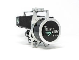
View full detailsTrueView 515 3D imaging system GeoCues TrueView 515 is simply the best performing mid-range LIDAR/camera system. This compact 3D imaging system f...
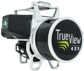
View full detailsTrueView 435 is the most economical platform for utility-grade mapping. GeoCue's TrueView 435 is our next-generation compact 3D imaging system that...
View full details