

Topocad Volume Section
Standard shipping
Approximately 7-10 days delivery time
Volume section & tunnel
Topocad Volume Section is an add-on module that requires the Topocad Base Module.
(NOTE: Annual maintenance fee of 20% of the license value will be added starting next month)
Volume Section uses section templates in combination with terrain models, point clouds, road lines, profiles, and skew diagrams to create calculated sections and volumes of various kinds.
- Interactive volume calculation of areas
- All types of section templates can be used
- Graphical editing of sections, the sections can be edited in a large number of ways with interactive area and volume calculation
- The 3D road is created in a drawing
- Volume section creates cross sections and calculates volumes for all types of lines. The cross sections are graphically editable and have an interactive calculation of volumes
- There are a number of quick templates in Topocad for roads, water and sewerage and tunnels to quickly get started with your section templates.
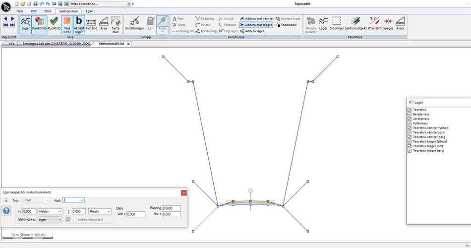
Topocad's section template is very intelligent and you can create any type of section template, both road, railway, water supply and tunnel. Volume calculation section uses ellipses and entire sections can be skewed.
The section templates are built using different vectors, fixed dimensions, slopes, relative dimensions, connections to models and layers, connections to layers, and more. In this way, you can create dynamic section templates that can follow different side lines or profiles and have different offset dimensions. The section templates can also use an unlimited number of included layers. This is both for internal layers such as wear layers, base layers, reinforcement layers, but also against a number of different terrain models. It is possible to calculate sections against soil, clay, reinforcement, rock, or, for example, against an existing road.
Interactive areas and quantities
In the calculated sections, all areas and quantities are interactive. You can edit one or many sections at the same time, with or without interpolation in the edits. Quantities are calculated directly. It is also possible to calculate sections against point clouds and the components can be changed at any time. For example, you can replace or update a terrain model, road line, profile or section and immediately get updated sections.
The sections can then be exported to LandXML for machine control in Novatron, Topcon, Trimble and several systems or to MBS for machine control in Georog. They can also be exported to terrain models or as sections and lines in a drawing. You can import calculated sections from LandXML format. You can then go back and create a section template from imported calculated sections.
Both calculated sections and terrain models created from sections can be referenced to a drawing in Topocad for a direct view of how the calculated sections will look. Topocad also supports a wide range of machine control formats and can import designs from other systems.
Tunnel sections
Tunnel mainly works with tunnel design, calculation and accounting. You can create tunnel sections using ready-made quick templates. Tunnel also handles point clouds. Areas can be calculated between intersection lines and you can also calculate a geological top profile.
Tunnel management takes place in three major stages:
- Creation of the theoretical tunnel section(s) with graphical editing and interpolation between different section elements. The sections can be built up using lines. Different types of sections can be used in the tunnel.
- Measurement of points and a comparison of these points and the theoretical tunnel section. The location of each point is compared with its theoretical location and a terrain model of the tunnel is created.
- This terrain model and the theoretical terrain model are compared with each other and different types of reporting in terms of volumes, areas and lengths can be obtained in a variety of ways.
Søkeord: